Southern California faces flood risk as storm begins to ease
Published in Weather News
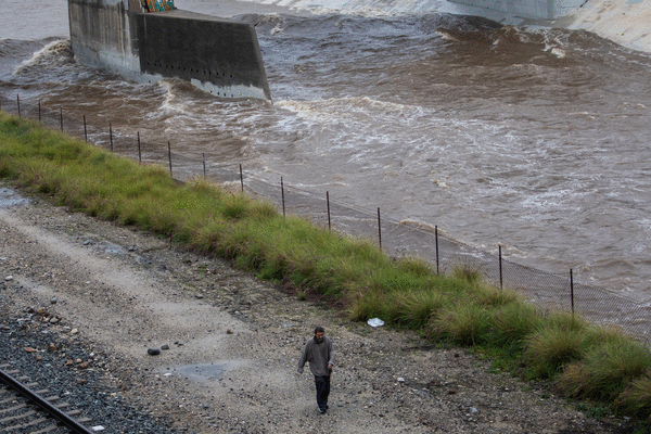
Coastal communities in Southern California braced for more rain and flash floods even as a powerful Christmas storm began to ease on Thursday evening, with a state of emergency still in place for Los Angeles and neighboring counties.
The potential for flooding will be high through Friday, as more showers and thunderstorms pass through the area, the National Weather Service said in a bulletin at about 2.30pm Pacific Time. Dry and warmer weather is expected to return for the rest of the weekend.
The historic storm, which has pummeled the region over the holiday, has brought with it road closures, flooded freeways and flight delays. It has also prompted evacuations in Los Angeles County and Orange County canyon communities. Three people have now died as a result of the storm, according to the Los Angeles Times.
Several locations including Santa Barbara and Montecito are expected to see flash floods, according to a NWS warning at 6.30pm Pacific Time. Rainfall totals in coastal hills near Malibu had exceeded 4 inches in 48 hours by Thursday morning.
The heavy rains are particularly worrying for communities devastated by massive wildfires nearly a year ago, including Pacific Palisades and Altadena. The charred-off vegetation makes the land impervious to soaking up the water, increasing the risk of landslides, mudslides and power outages.
It’s a risk that will persist when atmospheric rivers strike Southern California, and until the soil recovers and vegetation grows back.
“Those soils are still hydrophobic, which means that rain just runs off like it’s hitting hard dirt or concrete,” said Scott Kleebauer, a meteorologist at the Weather Prediction Center. “There are burn scars that have lasted for four or five years before you see any improvement.”
A combination of factors is making it a once in five-to-10-year weather event, he said.
A trough of low pressure that stretches across the Pacific Ocean is pushing wet air right up against the coastal mountains in Southern California, said Kleebauer. “It’s called the Pineapple Express because the moisture feed extends all the way back to Hawaii,” he said.
California has pre-positioned emergency response resources across the state, including 55 fire engines and 10 swiftwater rescue teams, according to a statement from California Governor Gavin Newsom.
The wet air is hitting California at the perfect perpendicular angle for maximum rainfall. “You get this tropical moisture source forced into the mountains and then it just rains itself out,” he said. “This is impacting one of the biggest travel days of the whole year. That is definitely going to thwart plans for a lot of people.”
San Francisco International is experienced flight delays of more than two hours because of high winds, according to the Federal Aviation Administration. Santa Barbara’s airport was closed for about four hours due to flooding.
Up in the mountains, Mammoth Mountain said it expected to open its main lodge at 10 a.m. local time due to ongoing heavy snowfall and storm conditions. The resort expected as many as 24 inches of total daytime snow accumulation on Thursday, according to its website.
____
(With assistance from Robin Paxton, Derek Wallbank, Lisa Pham and Naureen S. Malik.)
©2025 Bloomberg L.P. Visit bloomberg.com. Distributed by Tribune Content Agency, LLC.


Comments