Hurricane center says system could move across Florida, develop in Gulf
Published in News & Features
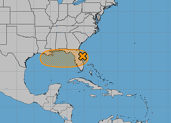
The National Hurricane Center said Tuesday a system moving over Florida remains disorganized, but could develop into the season’s next tropical depression or storm after it moves over land and into the Gulf this week.
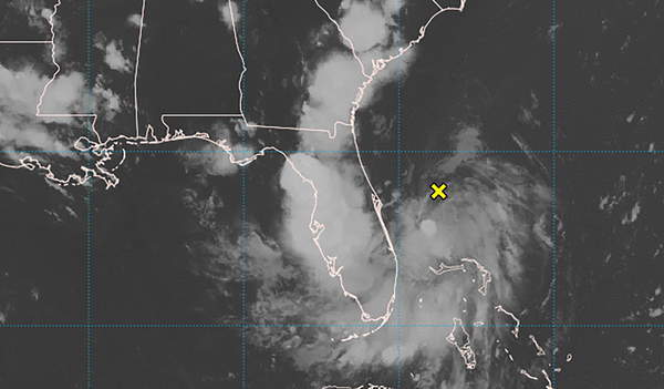
As of the NHC’s 2 p.m. Eastern time advisory, the center of the low pressure area that has been drenching the state with rounds of showers and thunderstorms since Sunday had moved from the Atlantic onto land on Florida’s northeast coast.
“This system is currently producing disorganized shower and thunderstorm activity, and little development is expected through (Tuesday) night while the center is over land,” forecasters said.
“Once the system reaches the northeastern Gulf on Wednesday, environmental conditions appear generally favorable for additional development, and a tropical depression could form while the system moves across the northeastern and north-central Gulf and approaches the coast of Louisiana on Thursday.”
The NHC gives it a 40% chance to develop in the next two to seven days.
“Regardless of development, heavy rainfall could produce localized flash flooding over portions of Florida through Wednesday,” forecasters said. “Heavy rainfall could also cause flash flooding for portions of the north-central Gulf Coast beginning Wednesday and continuing through Friday.”
If it does develop into a named storm, it could become Tropical Storm Dexter.
The National Weather Service in Melbourne said the system could drop up to 4.5 inches of rain in certain parts of Central Florida through Wednesday, although most of the region is forecast to see about 1 inch.
“While everywhere will not see continuous rain all day, forecast trends expect widespread coverage of showers and storms (~80-90%) with some areas seeing multiple rounds,” according to the NWS forecaster’s discussion
Minor flooding could hit some low lying and poor drainage areas, while there is a small chance for some stronger storms to bring wind gusts of 40-50 mph, the NWS stated.
As the system moves west, moisture will remain into Wednesday.
The state was previously doused by rains associated with what developed into Tropical Storm Chantal earlier this month. That storm ended up striking the Carolina coast and dumped flooding rains inland.
Before the start of hurricane season, the National Oceanic and Atmospheric Administration had forecast an expected 13 to 19 named storms for the year, of which 6 to 10 would grow into hurricanes. Three to five of those would develop into major hurricanes of Category 3 strength or higher.
Researchers out of Colorado State University this week, though, updated their forecast saying they expect the season to be slightly less busy than what they had predicted earlier this year.
Hurricane season runs June 1 to Nov. 30.
©2025 Orlando Sentinel. Visit at orlandosentinel.com. Distributed by Tribune Content Agency, LLC.


Comments